
FINAL SOLUTION TO China's ARTIFICIAL ISLANDS built within other Nations' EEZ ; should be destroyed as they are just mere squaters according to international law, its neighbors, or marine life, and tribunal rules
To stake its claim in the strategic South China Sea, China is building airstrips, ports, and other facilities on disputed islands and reefs. Scientists say the activities are destroying key coral reef ecosystems and will heighten the risks of a fisheries collapse in the region.
In the late 1980s, marine biologist John McManus and his colleagues made a surprising discovery while studying near-shore Philippine reefs in the South China Sea: Some fish species seemed to disappear, only to reappear a year or two later. “We figured they weren’t coming from other parts of the coast because the entire South China Sea, with the exception of Brunei, is equally overfished,” says McManus, a professor of marine biology and fisheries at the University of Miami.
But the South China Sea’s rich natural heritage, long threatened by overfishing, now faces a new ecological danger: A campaign by China to build artificial islands on disputed reefs in the Spratlys and elsewhere in the sea. China’s island-building initiative signals an aggressive stance intended to secure dominance in the South China Sea, a strategic area that contains some of the world’s busiest shipping lanes and is a potential source of oil deposits.
Over the past several years, Chinese President Xi Jinping has ordered engineers to pile sand onto some of the sea’s disputed offshore reefs, mostly in the Spratlys, with the apparent goal of building military bases there. Satellite imagery shows that China has so far constructed seven artificial islands in the Spratlys, and added ports, radar equipment, and airstrips. Three of the seven islands were designed as military bases, U.S. military officials say, and one has an anchorage larger than Hawaii’s Pearl Harbor. Marine scientists worry that the next target for dredging and construction will be Scarborough Shoal off the Philippine coast — which, like the Spratlys, is also known for its rich biodiversity.
Based on satellite information, computer-modeling data, and previous studies of human impacts on coral reefs, scientists are concerned that China’s campaign may be causing irreparable damage. Coral reefs in the Spratlys and other offshore regions, including the Paracel Islands and Scarborough Shoal, supply larvae for fisheries that feed hundreds of millions of people. They also are a living seed bank that could help the region’s marine communities deal with the long-term impacts of climate change.
“You’re talking about destroying the equivalent of seven worldwide natural heritage areas,” says one expert.
The scientists’ concerns stem partly from the island-construction process. Ships more than 300 feet long have been dredging deep-water channels and harbors, while smaller boats have dredged in shallower waters around reef flats and lagoons by digging up corals with their propellers, according to a forthcoming study by McManus. Both activities produce plumes of sand and silt that coat living reefs and block their access to sunlight. Deep-water dredging can also lower the existing seafloor by up to 30 feet, the study said, changing wave patterns and inhibiting the growth of the red algae that are essential to reef calcification and sedimentation.
Additional local and regional damage to reefs and fish stocks will occur, scientists say, if China turns some of the new artificial islands on the Spratlys into harbors for the country’s commercial fishing fleet.
“What you’re essentially talking about is destroying the equivalent of seven worldwide natural heritage areas,” says Kent Carpenter, a professor at Old Dominion University in Virginia who has studied coral reefs in the Philippines for four decades.
The long-term environmental impacts of China’s activities on the seven Spratly reefs it occupies may never be known unless the Chinese military allows independent experts to conduct research there, scientists say. But nearly six square miles of artificial islands have been built recently on disputed reefs in the sea, primarily in the greater Spratly Islands, according to the McManus study. Vietnam, Malaysia, Taiwan, and the Philippines accounted for just a tiny percentage of that construction, the study said, while China’s activities were responsible for 99 percent of the resulting damage to offshore coral reefs.
Although six square miles may seem like a small area, the McManus study indicates that the total damage from island building and dredging has already affected more than 10 percent of the Spratlys’ total shallow reef area.
Slide bar from left to right to view satellite images showing construction on Gaven Reef in the South China Sea. (Image courtesy of the Maritime Awareness Project)
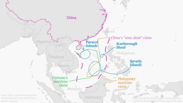
China has long claimed offshore territories in as much as 90 percent of the South China Sea. Its claims overlap with competing ones by Vietnam, the Philippines, and other nations. Tensions over the claims have simmered for decades, and some countries have conducted limited land reclamation work on disputed islands and atolls.
In July, the Philippines won a landmark case at a United Nations tribunal, successfully challenging China’s territorial claims in the sea. (Both McManus and Carpenter worked as paid science advisors to the Philippines on the case.) But President Xi has vowed to ignore the tribunal’s ruling, and some analysts think that China’s island-building efforts could raise geopolitical tensions and eventually lead to military conflict with rival claimants or the United States.
At the center of this drama lie the 12 main islets and more than 100 coral reefs of the Spratlys. Scientists describe the Spratlys as biological “stepping stones” for successive generations of corals and fish, meaning that larvae float hundreds of miles toward the Spratlys on ocean currents and stop in eddies near their corals to breed. Successive generations then travel further to create or repopulate marine communities elsewhere in the South China Sea, the Gulf of Thailand, or the Coral Triangle between Indonesia, the Philippines, and the Solomon Islands.
The Spratlys are “positioned very neatly to transfer biodiversity” across open water, says Clive Wilkinson, the former lead coordinator for the non-profit Global Coral Reef Monitoring Network. In addition to producing larvae, the Spratly reefs also function as biological “roadside cafes” for migratory fish, including tuna, that travel through the South China Sea on their way to the Indian Ocean and stop at the Spratlys to feed, he adds. “So any damage to them [the reefs] will have long-term repercussions,” says Wilkinson.
The South China Sea is chronically understudied, in large part because so many of its offshore rocks, reef, and atolls are military-patrolled zones that scientists cannot access. Chou Loke Ming, a coral reef expert at the National University of Singapore, says that nearly all on-the-ground scientific research on the South China Sea has so far been confined to near-shore areas where territorial ownership is not as murky as it is in the Spratlys.
But the existing science already paints a portrait of abundant biodiversity. For example, a 2015 computer-modeling study found that larvae from the coral species Acropora millepora, whose intricate branches help to shelter other organisms, float from the Spratlys across large swathes of the South China Sea and the Coral Triangle, “further highlighting the importance of the Spratly Islands to the greater region.” And a 2015 species survey said previous estimates of the South China Sea’s reef biodiversity have been “exceedingly low,” largely because of a lack of data for the Spratlys and some reefs off the Philippine island of Luzon.
Scientists think the Spratly reefs’ genetic diversity could help them weather the impacts of storms, ocean acidification, and other impacts linked to global warming. Larvae from the reefs could help repopulate distant marine communities that are less biologically resilient. If patches of biodiversity “blink out” occasionally across the South China Sea, “the idea is that if you have a lot of exchange, they’ll be reseeded in the near future,” says Eric Treml, a marine biologist at the University of Melbourne who has created computer models of regional fish-larvae movement.
Slide bar from left to right to view satellite images showing construction on Mischief Reef in the South China Sea. (Image courtesy of the Maritime Awareness Project)
Scientists say China’s island building may imperil that system of genetic diversity and biological connectivity. But how great is the cumulative threat from reef building and fishing? McManus estimates that China has already caused 55 square miles of “decadal-scale” damage through giant-clam harvesting and seafloor dredging near its new islands. That is worrying because seafloor dredging can kill corals by blocking their access to sunlight as has happened near Australia’s Great Barrier Reef, where sediment plumes extended for up to 28 miles from a seafloor dredging site.
By contrast, only 6.5 square miles of South China Sea reefs have been damaged by China’s island building and dredging for channel and harbor projects, according to McManus’ forthcoming study. Yet he describes that damage as “essentially permanent.”
“You cannot grow a coral on an airstrip because they don’t grow on airstrips; they grow underwater,” says Edgardo D. Gomez, a marine biologist and a professor emeritus at the University of the Philippines. And because the Spratly reefs have such a high degree of species endemism, Gomez adds, “We may have lost a number of species that we never discovered.”
Scientists also worry that China’s island-building campaign could exacerbate the risk of a fisheries collapse in the South China Sea. Decades of commercial trawl fishing in the sea’s coastal areas have already led to declining catches in most of its fisheries, and many Chinese and Southeast Asian fishing fleets — some with support from government programs — have begun to target deep-water habitats, according to the Fisheries Center at the University of British Columbia.
The Spratlys and other offshore reefs have long been somewhat protected from these pressures because fishermen saw them as difficult and dangerous to access, scientists say. But China’s new islands could change the equation by providing offshore harbors for Chinese fishing fleets. Wilkinson says that once ports are established on the new islands, “fishing boats will use the area more and more until eventually they deplete populations.”
In June, China’s State Oceanic Administration said in a statement that environmental protection measures, including advanced dredging techniques, had been implemented during planning and construction of its artificial islands, and that the islands would eventually have facilities that deal with environmental protection. “Impact on coral reef ecology is localized, temporary, controllable, and restorable,” the agency added. Two coral reef experts from China — at the Chinese University of Hong Kong and the government’s South China Sea Institute of Oceanology — did not respond to interview requests for this article.
Carpenter says the South China Sea is so politically sensitive that marine biologists from Taiwan, Hong Kong, and mainland China typically do not feel comfortable discussing the ecological impacts of the island-building campaign in public. But in private, he adds, “they’ll tell you they’re incensed, just like we are.”
Within the short span of a year, China’s rapid construction of artificial islands in the disputed Spratlys has radically changed the geographical and security landscapes in the South China Sea.
This island construction has so far created over eight million square metres of real estate in the open sea, outstripping other countries’ reclamation activities by far, and shows no sign of abating. Hundreds of millions of tons of sand and coral have been dredged from the seabed and dumped atop fragile coral reefs that are vital components of the maritime ecology. Marine experts expect that the work has already caused disastrous and essentially irreversible environmental impacts.
The newly created and enlarged islands will be infrastructure that facilitates China’s projection of force and assertion of control not just in the disputed Spratlys area but also over most of the South China Sea, deep into the exclusive economic zones (EEZs) that by any reasonable interpretation of international laws on maritime delimitation would rightfully belong to other countries. Although conflicting claims have existed over the islands and these EEZs for decades, a precarious balance has endured until now partly because China’s nearest military infrastructure is hundreds of miles further to the north. Defence planners in other claimant countries now have to face a future without this protection by distance.
Another concern is whether China will to use the newly created or enlarged islands to attempt to make new maritime claims. First, China might well claim a 12-nautical-mile territorial sea, or some sort of vague “military alert zone”, around each of Mischief Reef and Subi Reef, which would infringe on the international community’s the freedom of navigation and overflight that currently exists these areas. Second, China might assert territorial seas around other newly created or enlarged islands that are close to islands being garrisoned by other countries, which would bring it into direct conflicts with the other claimants. Third, the creation and enlarging of the islands may embolden China in its claim for EEZ for the entire Spratly archipelago, exacerbating the maritime disputes in the region.
China justifies the island building by arguing that “China’s activities on relevant islands and reefs of the Nansha Islands fall entirely within China’s sovereignty and are totally justifiable.”[1] Some analysts have argued further that it is not breaking any maritime law. However, these arguments can be shown to be flawed in a number of respects.
First, Fiery Cross Reef, Johnson South Reef, Cuarteron Reef, Hughes Reef and Gaven Reef are the subjects of a sovereignty dispute. It is therefore bad faith for a claimant to completely and irreversibly alter their geographical characters. If one day an international court is given the jurisdiction to resolve the dispute and rules that these islands belong to a country other than China then the damage to these reefs from today’s island building activities has already and irretrievable impaired that country’s rights.
Second, since Mischief Reef and Subi Reef in their natural state are under water at high tide and more than 12 nautical miles from other islands, customary international law does not allow any country to claim sovereignty over them. Therefore the island building activities at these reefs cannot be within China’s sovereignty. Furthermore, it would be illegal for China or any country to claim sovereignty over the newly created artificial islands at these locations.
Third, the United Nations Convention on the Law of the Sea (UNCLOS) does not allow China to use the artificial islands at Mischief Reef and Subi Reef to claim 12-nautical-mile territorial seas or EEZs beyond: artificial islands are only entitled to a safety zone that can extend to at most 500 metres.
Fourth, China is violating UNCLOS articles 192 and 123, which are on the protection of the marine environment, especially in enclosed and semi-enclosed seas such as the South China Sea. Article 192 states that “States have the obligation to protect and preserve the marine environment”, while article 123 requires the countries bordering an enclosed sea to “coordinate the implementation of their rights and duties with respect to the protection and preservation of the marine environment”. While each of the parties in the Spratlys dispute would naturally think that it, and it alone, has the rights to build on the disputed islands and reefs, it is undeniable that they all have a duty to protect and preserve the marine environment of the semi-enclosed and environmentally vulnerable South China Sea.
In its 2003 ruling on the Malaysia vs Singapore dispute over the latter’s reclamation activities, the International Tribunal on the Law of the Sea (ITLOS) directed “Singapore not to conduct its land reclamation in ways that might cause irreparable prejudice to the rights of Malaysia or serious harm to the marine environment, taking especially into account the reports of the group of independent experts.” Singapore complied with the tribunal’s ruling. China, however, has completely disregarded it obligations to UNCLOS by dredging hundreds of millions of tons of sand and coral from the seabed and dumping them over eight million square metres of coral reefs that are vital fish spawning grounds, without any assessment by independent experts, and without any coordination or even consultation with other littoral countries.
Fifth, the fact that the Spratlys area is subjected to territorial and maritime disputes brings us to another violation of UNCLOS. Articles 74 and 83 of the Convention requires that in areas of conflicting EEZ or extended continental shelf claims, the claimants “in a spirit of understanding and cooperation, shall make every effort to enter into provisional arrangements of a practical nature and, during this transitional period, not to jeopardize or hamper the reaching of the final agreement.” In its 2004 ruling on the Guyana vs Suriname dispute, the Permanent Court of Arbitration (PCA) has interpreted this clause to mean that the claimants are not allowed to unilaterally cause permanent changes to the area under dispute.
By all accounts, Mischief Reef is an area of EEZ under dispute, while Subi Reef could be an area of EEZ or extended continental shelf under dispute, where UNCLOS articles 74 and 83 and the Guyana-Suriname ruling are clearly applicable. The building of islands on Mischief Reef and Subi Reef clearly violates these articles.
Unlike Mischief Reef and Subi Reef, Fiery Cross Reef , Johnson South Reef, Cuarteron Reef, Hughes Reef and Gaven Reef are either naturally above high tide or situated within 12 nautical miles of other islands. According to UNCLOS, they are surrounded by territorial seas. Therefore, China’s island building at these reefs takes place within the territorial seas and it might seem that UNCLOS articles 74 and 83 and the Guyana-Surinam ruling (which apply only to the EEZ and the extended continental shelf) are not relevant. However, a closer look suggests otherwise. It is well known that coral reefs are important fish spawning grounds of the oceans and sea, and their destruction affects fish stock far beyond the reefs’ adjacent waters. Massive island building on reefs can therefore have permanent effects on the EEZ beyond these reefs’ territorial seas. In the case of the Spratlys, that EEZ is disputed, therefore UNCLOS articles 74 and the Guyana-Surinam ruling apply, which means actions that cause permanent changes to that EEZ are illegal even if the actions themselves take place in the territorial sea.
In summary, China’s massive island building is both a provocative alteration of the security situation in the South China Sea and blow for the marine environment, but it cannot be justified either as “entirely within China’s sovereignty” or as consistent with maritime law. In fact, if China claims sovereignty over Mischief Reef and Subi Reef and maritime zones based on those features, that will be an audacious attempt to rewrite international law.
China has no respect for international law, its neighbors, or marine life, and tribunal rules

Chinese dredging vessels seen in the waters around Mischief Reef in the disputed Spratly Islands in the South China Sea.
The tribunal’s findings will have far-reaching impacts. The ruling essentially squashes any justification China might have had for harassing ships passing by its controversial artificial islands,
blocking Filipino fishermen
from areas like Scarborough Shoal, or interfering with other nations’ attempts to explore for oil off their coasts.
ADVERTISEMENT
Indeed the tribunal ruled that China’s nine-dash line is essentially illegal and without basis under the 1982 UN Convention on the Law of the Sea (UNCLOS), which is at the core of modern maritime law and has been signed by over 160 nations (including China). The treaty for instance grants exclusive economic zones (EEZs) to coastal nations extending 200 nautical miles from the shore baseline, giving them sole exploitation rights over all natural resources in that zone.
Below are some of the main points of the 500-page “award” issued by the Permanent Court of Arbitration, in The Hague:China’s “claims to historic rights, or other sovereign rights or jurisdiction” related to the “nine-dash line” are unlawful, the tribunal found, “to the extent that they exceed the geographic and substantive limits of China’s maritime entitlements” under UNCLOS. The treaty supersedes “any historic rights or other sovereign rights or jurisdiction” and there was “no evidence that China has historically exercised exclusive control over the waters or their resources.”
These are the countries with the highest and lowestminimum wages
China built a large artificial island on Mischief Reef, a low-tide elevation located in the EEZ of the Philippines. The construction “caused permanent, irreparable harm to the coral reef ecosystem and permanently destroyed evidence of the natural condition of the features in question.” The project infringed the Philippines’ sovereign rights in its EEZ and continental shelf.
China has prevented the Philippines from using non-living natural resources and fishing in the waters that lie within 200 nautical miles of its EEZ, infringing on the country’s sovereign rights. China’s People’s Liberation Army protected its own fishermen in the Philippines economic zone, while blocking Filipino fishermen from traditional waters—at one point rigging together 28 utility boats to prevent others from entering a shoal.
Chinese fishermen have been harvesting endangered species including corals, sea turtles, and sharks at at least two shoals in the Spratly Islands—and Beijing has tolerated and protected these activities. In addition, China’s artificial island-building program at seven reefs in the Spratly Islands has caused “devastating and long-lasting” damage to the marine environment. For instance, 60% of the shallow reef habitat at the seven reefs has been directly destroyed, a 2016 study found.
China sent law enforcement ships into the sea surrounding the Scarborough Shoal, creating “serious risk of collision and danger” to Philippine vessels and personnel. In some cases, these Chinese ships passed the Filipino ships at distances of 100 or fewer yards (91 meters), almost “ramming” one ship.
The tribunal agreed with the Philippines that Scarborough Shoal, Johnson Reef, Cuarteron Reef, and Fiery Cross Reef are high-tide features and that Subi Reef, Hughes Reef, Mischief Reef, and Second Thomas Shoal were submerged at high tide in their natural condition. (Low tide features have no territorial sea of their own, unless they are within a certain distance of a country’s mainland or undisputed island).
Throughout the course of the proceedings, China “aggravated and extended the disputes” by “dredging, artificial island-building, and construction activities” in the areas in question.
It “goes without saying that both Parties are obliged to resolve their disputes peacefully and to comply with the Convention and this Award in good faith,” the ruling concludes.
China’s foreign-affairs ministry stated soon after the ruling was released that “the People’s Republic of China solemnly declares that the award is null and void and has no binding force.” Beijing has long maintained that it will ignore today’s ruling, and it refused to participate in the case at all. Indeed it resorted to insulting the tribunal, with state-controlled media recently describing the PCA as a “law-abusing tribunal” with “widely contested jurisdiction.”
But it might be hard for China to ignore a ruling that so thoroughly, and in such fine detail, discredits its position.
A long time coming
The Philippines filed its case with the international court in 2013, asking the tribunal to rule on various aspects of China’s sweeping claims.

Albert F. del Rosario—the Philippines’ foreign affairs secretary—at the Permanent Court of Arbitration in July 2015.Image: Permanent Court of Arbitration
In recent years China has been acting aggressively in the sea, justifying its actions based largely on the nine-dashed line, which first appeared in a map published in the 1940s (originally with 11 dashes). Beijing submitted the map to the United Nations in 2009 (pdf), saying that China had “sovereign rights and jurisdiction over the relevant waters as well as the seabed and subsoil.”
ADVERTISEMENT
The Philippines and other nations immediately objected.
For the Philippines, tensions ratcheted up in 2012, when its navy apprehended Chinese fishing trawlers illegally operating at Scarborough Shoal—well within its EEZ. After a standoff between Chinese and Philippine forces, the US mediated a deal in which both sides were to pull back from the shoal while the dispute was negotiated. The Philippine forces left, but the Chinese ones remained, gaining control that they still have today.
Significantly, the tribunal ruled that none of the islands in the contested Spratly archipelago, nor Scarborough Shoal, generate an EEZ. Instead, the most that any “island” in question generates is a territory of 12 nautical miles.
To simplify a bit, any feature that in its natural state is under water at low tide is not an island. A feature that does jut above the water at high tide is considered an island. But if it’s just a rock, it generates nothing more than a territorial sea of 12 nautical miles. If it’s a “real” island capable of sustaining human habitation or economic life of its own, it might generate an EEZ. Under the law, these determinations are made based on the natural state of the feature—regardless of what’s been built on top of them.
Leading up to the ruling China pushed for what it calls a “win-win” strategy in the sea (pdf, p. 19), where if other nations have oil and gas reserves that fall within both their own EEZs and China’s nine-dash line, then the two parties should share revenue on the project. Needless to say, other nations are not too keen on the idea (pdf, page 19). Now they have a ruling to cite showing they don’t need to share these resources with China.
No comments:
Post a Comment