

|  Fukushima: A Nuclear War without a War |
The Unspoken Crisis of Worldwide Nuclear RadiationMichel Chossudovsky
The World is at a critical crossroads. The Fukushima disaster in Japan has brought to the forefront the dangers of Worldwide nuclear radiation. The horse is already out of the barn here. This plant’s been leaking for two years. And finally, now, the radioactive water has made it to the ocean. But my experience with underground water is that – if it is serious at the ocean, it is more serious as you move away from the ocean. So, spike of radiation continues to move to the ocean. The Japanese are proposing putting in a barrier to prevent the water from entering the ocean. That is two years too late and will be too late by the time they construct that barrier. But the barrier also causes another problem. If the water can’t go anywhere into the Pacific Ocean, it is going to build up onsite, which means that the nuclear reactors themselves will become unstable. The water can pull underneath the nuclear buildings and if there is an earthquake, in fact the nuclear buildings could topple. So, by solving one problem, they are creating another problem. The crisis in Japan has been described as “a nuclear war without a war”. In the words of renowned novelist Haruki Murakami:
Two years after the the Great East Japan Earthquake of March 11, 2011, and the following tsunami and nuclear disaster, a large area around the failed Fukushima nuclear plant is still considered an exclusion zone. Namie, a small city just north of the nuclear power plant, was evacuated shortly after the quake, and its 21,000 townspeople have been unable to return since, leaving it a ghost town. At the invitation of local officials, Google recently deployed its camera-equipped vehicles to Namie to create a street view map of the deserted town so residents can see their abandoned homes, and the world can witness the remains of the disaster. On Google's Map blog, Namie's Mayor Tamotsu Baba said, "Ever since the March disaster, the rest of the world has been moving forward, and many places in Japan have started recovering. But in Namie-machi time stands still... Those of us in the older generation feel that we received this town from our forebears, and we feel great pain that we cannot pass it down to our children." I've collected some of the scenes captured by the Google Maps crew below, a glimpse into an otherworldly landscape a few kilometers north of the Fukushima nuclear plant.
The empty shell of the tsunami-damaged Tanashio meeting house stands in Namie town, Japan, just north of the failed Fukushima nuclear power plant. Google recently sent its Street View team into Namie, still within the nuclear exclusion zone, to document the empty streets and fields, deserted now for more than two years. See this on the map. (© Google, Inc.)
The roof of a collapsed house, damaged by the 2011 earthquake, lies partially in a road in Namie, Japan. See this on the map.(© Google, Inc.) #
Bicycles sit abandoned in a parking lot near Namie's train station. See this on the map. (© Google, Inc.) #
Plants have grown undisturbed for two years, and are beginning to encroach on the streets. See this on the map.(© Google, Inc.) #
A jumble of stones lie in a cemetery just a few hundred feet from the shoreline. The stones and surrounding buildings were swept up by the massive tsunami two years ago. See this on the map. (© Google, Inc.) #
The now-empty Ukedo fishing port, formerly filled with 140 fishing vessels. See this on the map. (© Google, Inc.) #
A partially-collapsed business in Namie leans heavily on a vending machine. See this on the map. (© Google, Inc.) #
Fishing boats and mountains of debris are piled near the shore, as cleanup efforts remain incomplete. See this on the map.(© Google, Inc.) #
A structure collapsed onto a Namie street. See this on the map. (© Google, Inc.) #
Abandoned apartment buildings, and an empty parking lot, with weeds growing from every crack. See this on the map.(© Google, Inc.) #
Smashed pieces of boats lie on and near the empty shell of a structure on Ukedo harbor. See this on the map. (© Google, Inc.) #
The Google Street View car catches its reflection in a mirror near an overgrown residential driveway in Namie. See this on the map.(© Google, Inc.) #
A smashed vehicle sits rusting against a sea wall on Ukedo harbor. See this on the map. (© Google, Inc.) #
A heavily-damaged structure on Ukedo harbor. See this on the map. (© Google, Inc.) #
A collapsed building beside an empty restaurant, in Namie. See this on the map. (© Google, Inc.) #
One of the few still-standing structures near namie's waterfront. See this on the map. (© Google, Inc.) #
Debris strewn along the roadside, near Namie's Pacific shoreline. See this on the map. (© Google, Inc.) #
A shattered house stands alone among a field of debris and empty foundations, in an area badly damaged by the tsunami. See this on the map. (© Google, Inc.) #
A roadside memorial near Namie's shoreline. See this on the map. (© Google, Inc.) #
A partially-collapsed structure knocked over a wall, trapping the Volkswagen in Namie. See this on the map. (© Google, Inc.) #
The wreckage of tractors and other vehicles line a road near Namie's shore. See this on the map. (© Google, Inc.) #
Most roads in Namie lead to dead ends, either due to earthquake damage, or to enforce the imposed exclusion zone. See this on the map. (© Google, Inc.) #
Another collapsed house on the streets on Namie. See this on the map. (© Google, Inc.) #
Smashed vehicles lie strewn about in the fields near Namie's shore -- left where the tsunami dropped them two years ago. See this on the map. (© Google, Inc.) #
Fishing nets and other debris spills out of the empty Ukedo meeting house. See this on the map. (© Google, Inc.) #
Crows line a small damaged bridge over the Ukedo River, on the north side of Namie. See this on the map. (© Google, Inc.) #
An abandoned tractor, partially overgrown. See this on the map. (© Google, Inc.) #
The exterior of Ukedo Elementary School, heavily damaged by the tsunami. The school's 92 students were able to evacuate before disaster struck. See this on the map. (© Google, Inc.) #
A hand-washing station, just inside Ukedo Elementary School. See this on the map. (© Google, Inc.) #
On the second floor of Ukedo Elementary School, long-abandoned computer monitors have become perches for sea birds seeking shelter, who have smeared the screens with droppings. See this on the map. (© Google, Inc.) #
Writing on a blackboard inside Ukedo Elementary School says "I love Ukedo Elementary School. I'll definitely return!" See this on themap. (© Google, Inc.) #
A banner for the 2011 graduation ceremony remains inside the damaged Ukedo Elementary School gymnasium. See this on themap. (© Google, Inc.) #
Standing atop the Ukedo Elementary School, looking south, one can make out a few tall structures in the distance, belonging to the Fukushima Daiichi Nuclear Plant, a few kilometers to the south. See this on the map. (© Google, Inc.) Nuclear radiation –which threatens life on planet earth– is not front page news in comparison to the most insignificant issues of public concern, including the local level crime scene or the tabloid gossip reports on Hollywood celebrities. While the long-term repercussions of the Fukushima Daiichi nuclear disaster are yet to be fully assessed, they are far more serious than those pertaining to the 1986 Chernobyl disaster in the Ukraine, which resulted in almost one million deaths (New Book Concludes – Chernobyl death toll: 985,000, mostly from cancer Global Research, September 10, 2010, See also Matthew Penney and Mark Selden The Severity of the Fukushima Daiichi Nuclear Disaster: Comparing Chernobyl and Fukushima, Global Research, May 25, 2011) Moreover, while all eyes were riveted on the Fukushima Daiichi plant, news coverage both in Japan and internationally failed to fully acknowledge the impacts of a second catastrophe at TEPCO’s (Tokyo Electric Power Co Inc) Fukushima Daini nuclear power plant. The shaky political consensus both in Japan, the U.S. and Western Europe is that the crisis at Fukushima has been contained. The realties, however, are otherwise. Fukushima 3 was leaking unconfirmed amounts of plutonium. According to Dr. Helen Caldicott, “one millionth of a gram of plutonium, if inhaled can cause cancer”. n a few days, Japan will mark the 2nd anniversary of the devastating Tohoku earthquake and resulting tsunami. The disaster killed nearly 19,000 across Japan, leveling entire coastal villages. Now, nearly all the rubble has been removed, or stacked neatly, but reconstruction on higher ground is lagging, as government red tape has slowed recovery efforts. Locals living in temporary housing are frustrated, and still haunted by the horrific event, some displaying signs of post-traumatic stress disorder. Collected below are a series of before-and-after interactive images. Click on each one to see the image fade from before (2011) to after (2013). [18 photo pairs] Use j/k keys or ←/→ to navigate Choose: 1024px 1280px
The tsunami-devastated Kesennuma in Miyagi prefecture, is pictured in this side-by-side comparison photo taken March 12, 2011 (left) and March 4, 2013 (right), ahead of the two-year anniversary of the March 11 earthquake and tsunami that damaged so much of northeastern Japan. (Reuters/Kyodo)
This before-after pair of images shows a private plane, cars and debris outside Sendai Airport in Natori, Miyagi prefecture on March 13, 2011, and the same area two years later, on February 21, 2013. [click image to view transition](Mike Clarke, Toru Yamanaka, Toshifumi Kitamura/AFP/Getty Images) #
A catamaran sightseeing boat washed by the tsunami onto a two-story tourist home in Otsuchi, Iwate prefecture on April 16, 2011, and (click to fade) the same area on February 18, 2013. [click image to view transition](Toru Yamanaka, Yasuyoshi Chiba, Toshifumi Kitamura/AFP/Getty Images) #
Residents crossing a bridge covered with debris in a tsunami-hit area of the city of Ishinomaki in Miyagi prefecture on March 15, 2011, and (click to fade) the same area nearly two years later on February 22, 2013. [click image to view transition](Kim Jae-Hwan, Toru Yamanaka/AFP/Getty Images) #
Residents look at a tsunami-damaged area of Minamisoma, Fukushima Prefecture, on March 12, 2011, and (click to fade) the same area on February 17, 2013. [click image to view transition](Toru Yamanaka, Kazuhiro Nogi, Toshifumi Kitamura/AFP/Getty Images) #
Rusted vehicles and tsunami debris in Ishinomaki, Miyagi prefecture, on March 19, 2011, and (click to fade) March 1, 2013. [click image to view transition] (Reuters/Kyodo) #
Tsunami debris covers a large area of Natori, near Sendai in Miyagi prefecture on March 13, 2011, and (click to fade) the same field on February 21, 2013. [click image to view transition] (Mike Clarke, Toru Yamanaka, Toshifumi Kitamura/AFP/Getty Images) #
A tsunami-hit area of Rikuzentakata, Iwate prefecture on March 29, 2011, and (click to fade) the same area on February 19, 2013.[click image to view transition] (Toru Yamanaka, Toshifumi Kitamura/AFP/Getty Images) #
The tsunami-devastated Minamisanriku, Miyagi prefecture, seen on March 13, 2011, and (click to fade) March 2, 2013. [click image to view transition] (Reuters/Kyodo) #
Residents walk past damaged cars on a street in a tsunami-damaged area of Tagajo, Miyagi prefecture on March 13, 2011, and (click to fade) the same street on February 21, 2013. [click image to view transition](Kim Jae-Hwan, Toru Yamanaka, Toshifumi Kitamura/AFP/Getty Images) #
A tsunami-hit street in Ofunato, Iwate prefecture on March 14, 2011, and (click to fade) the same scene as it appeared on February 19, 2013. [click image to view transition] (Toru Yamanaka, Toshifumi Kitamura/AFP/Getty Images) #
A rescue worker walks through rubble in the tsunami hit area of Minamisanriku, Miyagi prefecture on March 18, 2011, and (click to fade) the same area on February 20, 2013. [click image to view transition](Mike Clarke, Toru Yamanaka, Toshifumi Kitamura/AFP/Getty Images) #
A cherry blossom tree stands among tsunami debris in the city of Kamaishi, Iwate prefecture on April 20, 2011, and (click to fade) the same scene on February 18, 2013. [click image to view transition](Toru Yamanaka, Yasuyoshi Chiba, Toshifumi Kitamura/AFP/Getty Images) #
A catamaran sightseeing boat washed by the tsunami onto a two-story home in Otsuchi, Iwate prefecture on April 16, 2011, and (click to fade) the same structure on February 18, 2013. [click image to view transition](Toru Yamanaka, Yasuyoshi Chiba, Toshifumi Kitamura/AFP/Getty Images) #
On March 12, 2011, people evacuate down a road flooded by the tsunami in the city of Ishinomaki in Miyagi prefecture, click to fade the image and show the same road on February 22, 2013. [click image to view transition](Jiji Press, Toru Yamanaka, Toshifumi Kitamura/AFP/Getty Images) #
A 10-meter tall pine tree stands in Rikuzentakata, Iwate prefecture on March 29, 2011, shortly after the tsunami. Click to see the same scene nearly two years later, on February 19, 2013. It was the only tree to have survived the tsunami among some 70,000 trees located by the seashore to protect from salt, sand and wind damage, but later died. The crane (2nd image) is working on a memorial to the tree. [click image to view transition] (Toru Yamanaka, Toshifumi Kitamura/AFP/Getty Images) #
Tsunami-hit Ofunato, in Iwate prefecture on March 14, 2011, and (click to fade) the same scene as it appeared on February 18, 2013. [click image to view transition] (Toru Yamanaka, Toshifumi Kitamura/AFP/Getty Images) #
An image of the tsunami breaching an embankment and flowing into the city of Miyako, Iwate prefecture, taken by a Miyako City official on March 11, 2011, and (click to fade) the same scene on February 18, 2013, nearly two years later. [click image to view transition] (Jiji Press, Toru Yamanaka, Toshifumi Kitamura/AFP/Getty Images) # An opinion poll in May 2011 confirmed that more than 80 per cent of the Japanese population do not believe the government’s information regarding the nuclear crisis. (quoted in Sherwood Ross,Fukushima: Japan’s Second Nuclear Disaster, Global Research, November 10, 2011) The Impacts in Japan The Japanese government has been obliged to acknowledge that “the severity rating of its nuclear crisis … matches that of the 1986 Chernobyl disaster”. In a bitter irony, however, this tacit admission by the Japanese authorities has proven to been part of the cover-up of a significantly larger catastrophe, resulting in a process of global nuclear radiation and contamination:
Fukushima in the wake of the Tsunami, March 2011 Worldwide Contamination The dumping of highly radioactive water into the Pacific Ocean constitutes a potential trigger to a process of global radioactive contamination. Radioactive elements have not only been detected in the food chain in Japan, radioactive rain water has been recorded in California:
While the spread of radiation to the West Coast of North America was casually acknowledged, the early press reports (AP and Reuters) “quoting diplomatic sources” stated that only “tiny amounts of radioactive particles have arrived in California but do not pose a threat to human health.”
The spread of radiation. March 2011 Public Health Disaster. Economic Impacts What prevails is a well organized camouflage. The public health disaster in Japan, the contamination of water, agricultural land and the food chain, not to mention the broader economic and social implications, have neither been fully acknowledged nor addressed in a comprehensive and meaningful fashion by the Japanese authorities. Japan as a nation state has been destroyed. Its landmass and territorial waters are contaminated. Part of the country is uninhabitable. High levels of radiation have been recorded in the Tokyo metropolitan area, which has a population of 39 million (2010) (more than the population of Canada, circa 34 million (2010)) There are indications that the food chain is contaminated throughout Japan:
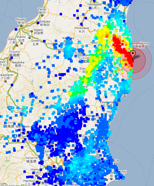
Japan’s industrial and manufacturing base is prostrate. Japan is no longer a leading industrial power. The country’s exports have plummeted. The Tokyo government has announced its first trade deficit since 1980. While the business media has narrowly centered on the impacts of power outages and energy shortages on the pace of productive activity, the broader issue pertaining to the outright radioactive contamination of the country’s infrastructure and industrial base is a “scientific taboo” (i.e the radiation of industrial plants, machinery and equipment, buildings, roads, etc). A report released in January 2012 points to the nuclear contamination of building materials used in the construction industry, in cluding roads and residential buildings throughout Japan.(See FUKUSHIMA: Radioactive Houses and Roads in Japan. Radioactive Building Materials Sold to over 200 Construction Companies, January 2012) A “coverup report” by the Ministry of Economy, Trade and Industry (May 2011), entitled“Economic Impact of the Great East Japan Earthquake and Current Status of Recovery“ presents “Economic Recovery” as a fait accompli. It also brushes aside the issue of radiation. The impacts of nuclear radiation on the work force and the country’s industrial base are not mentioned. The report states that the distance between Tokyo -Fukushima Dai-ichi is of the order of 230 km (about 144 miles) and that the levels of radiation in Tokyo are lower than in Hong Kong and New York City.(Ministry of Economy, Trade and Industry, Impact of the Great East Japan Earthquake and Current Status of Recovery, p.15). This statement is made without corroborating evidence and in overt contradiction with independent radiation readings in Tokyo (se map below). In recent developments, Sohgo Security Services Co. is launching a lucrative “radiation measurement service targeting households in Tokyo and four surrounding prefectures”. “A map of citizens’ measured radiation levels shows radioactivity is distributed in a complex pattern reflecting the mountainous terrain and the shifting winds across a broad area of Japan north of Tokyo which is in the center of the of bottom of the map.” “Radiation limits begin to be exceeded at just above 0.1 microsieverts/ hour blue. Red is about fifty times the civilian radiation limit at 5.0 microsieverts/hour. Because children are much more sensitive than adults, these results are a great concern for parents of young children in potentially affected areas. SOURCE: Science Magazine The fundamental question is whether the vast array of industrial goods and components “Made in Japan” — including hi tech components, machinery, electronics, motor vehicles, etc — and exported Worldwide are contaminated? Were this to be the case, the entire East and Southeast Asian industrial base –which depends heavily on Japanese components and industrial technology– would be affected. The potential impacts on international trade would be farreaching. In this regard, in January, Russian officials confiscated irradiated Japanese automobiles and autoparts in the port of Vladivostok for sale in the Russian Federation. Needless to say, incidents of this nature in a global competitive environment, could lead to the demise of the Japanese automobile industry which is already in crisis. While most of the automotive industry is in central Japan, Nissan’s engine factory in Iwaki city is 42 km from the Fukushima Daiichi plant. Is the Nissan work force affected? Is the engine plant contaminated? The plant is within about 10 to 20 km of the government’s “evacuation zone” from which some 200,000 people were evacuated (see map below).
The crisis in Japan has also brought into the open the unspoken relationship between nuclear energy and nuclear war. Nuclear energy is not a civilian economic activity. It is an appendage of the nuclear weapons industry which is controlled by the so-called defense contractors. The powerful corporate interests behind nuclear energy and nuclear weapons overlap. In Japan at the height of the disaster, “the nuclear industry and government agencies [were] scrambling to prevent the discovery of atomic-bomb research facilities hidden inside Japan’s civilian nuclear power plants”.1 (See Yoichi Shimatsu, Secret Weapons Program Inside Fukushima Nuclear Plant? Global Research, April 12, 2011) It should be noted that the complacency of both the media and the governments to the hazards of nuclear radiation pertains to the nuclear energy industry as well as to to use of nuclear weapons. In both cases, the devastating health impacts of nuclear radiation are casually denied. Tactical nuclear weapons with an explosive capacity of up to six times a Hiroshima bomb are labelled by the Pentagon as “safe for the surrounding civilian population”. No concern has been expressed at the political level as to the likely consequences of a US-NATO-Israel attack on Iran, using “safe for civilians” tactical nuclear weapons against a non-nuclear state.
After the disasters of March 11, tens of thousands were ordered to leave their homes in the vicinity of the damaged Fukushima Dai-ichi nuclear power station, some of their footprints now frozen in the mud. (© David Guttenfelder /National Geographic)
Two dogs scrap on Okuma's empty streets. In the early days of the crisis the no-go zone was alive with roaming farm animals and pets: cows, pigs, goats, dogs, cats, even ostriches. Often defying police patrols and barricades, volunteer rescuers rounded up and decontaminated some pets, returning them to their owners, and fed others. But by midsummer, a number of the pets had perished of starvation and disease. (© David Guttenfelder/National Geographic) #
Futon bedding is usually folded and stored in closets each morning. But residents had no chance to put their homes in order before their hasty exodus, prompted by evacuation orders on televised news conferences before dawn on March 12. This bedroom is in Okuma, less than three miles from the damaged nuclear plant. Town officials in the area have accused power company Tepco of violating its duty to warn them of the crisis. (© David Guttenfelder/National Geographic) #
In a gym in Hirono, residents in protective suits are briefed before being escorted to their homes for a June 8 visit and to retrieve a few small items. (There's no room on the bus for larger things.) Although the trips in were strictly controlled, a town official says that for the decontamination process - disposing of shoe covers, suits, caps, and masks and being screened for radiation - everyone and everything was waved through. (© David Guttenfelder/National Geographic) #
Evacuation drills are common in Japan's earthquake zones. So when the real thing happened in March, the children knew what to do - and expected to return in a few days. Months have gone by since the students fled. Still sitting in the classroom cubbies are the leather book bags that can cost several hundred dollars apiece and are one of a Japanese child's most valuable and cherished possessions. They will likely never be reclaimed. (© David Guttenfelder/National Geographic) #
An evacuee relaxes in her makeshift dwelling on the floor of the Big Palette convention center. The crammed emergency quarters lack privacy, and disease can spread rapidly. Older residents, who spent their lives in tight-knit rural communities, are often reluctant to move into temporary housing, isolated from friends and family. Social workers are trying to prevent a wave of kodoku-shi, or lonely death, among solitary seniors. (© David Guttenfelder/National Geographic) #
A deserted street inside the contaminated exclusion zone around the crippled Fukushima Dai-ichi nuclear power station, viewed through a bus window near Okuma, Japan, on November 12, 2011. (AP Photo/David Guttenfelder) #
A deserted field and buildings inside the contaminated exclusion zone around the Fukushima Dai-ichi nuclear power station, near Okuma, Japan, on November 12, 2011. (AP Photo/David Guttenfelder) #
A deserted neighborhood inside Japan's contaminated exclusion zone, near Okuma, Japan, on November 12, 2011.(AP Photo/David Guttenfelder) #
Units five and six of the Fukushima Dai-ichi nuclear power station, viewed through a bus window in Futaba, Japan, on November 12, 2011. Media allowed into Japan's tsunami-damaged nuclear power plant for the first time Saturday saw a striking scene of devastation: twisted and overturned vehicles, crumbling reactor buildings and piles of rubble virtually untouched since the wave struck more than eight months ago. (AP Photo/David Guttenfelder) #
The Unit 4 reactor building of the crippled Fukushima Dai-ichi nuclear power station, in Okuma, Japan, on November 12, 2011.(AP Photo/David Guttenfelder) #
A closer view of the Unit 4 reactor building of the Fukushima Dai-ichi nuclear power station, seen through a bus window in Okuma, Japan, on November 12, 2011. (AP Photo/David Guttenfelder) #
Workers in protective clothing walk to enter a radiation screening post after arriving at J-Village, a soccer training complex now serving as an operation base for those battling Japan's nuclear disaster at the tsunami-damaged Fukushima Dai-ichi nuclear plant, on November 11, 2011. (AP Photo/David Guttenfelder) #
An official from the Tokyo Electric Power Co. wears protective plastic bags over his shoes inside the emergency operation center at Fukushima Dai-ichi nuclear power station in Okuma, on November 12, 2011. (AP Photo/David Guttenfelder) #
Officials from the Tokyo Electric Power Co. and Japanese journalists pass by a newly built sea barricade next to the crippled Fukushima Dai-ichi nuclear power station in Okuma, on November 12, 2011. (AP Photo/David Guttenfelder) #
Parts of the heavily-damaged Fukushima Dai-ichi nuclear power station, viewed through a bus window in Okuma, on November 12, 2011. (AP Photo/David Guttenfelder) #
In this November 12, 2011 photo, workers in protective suits and masks wait to enter the emergency operation center at the Fukushima Dai-ichi nuclear power station in Okuma, Japan. The March 11 earthquake and tsunami caused massive death and destruction across northeastern Japan. But those who live near the crippled Fukushima Dai-ichi nuclear plant face a burden atop the losses they've already suffered: a fear of radiation that experts say could prove more unhealthy in the long run than the still-low levels of leaked radiation itself. (AP Photo/David Guttenfelder) #
Damage inside the Fukushima Dai-ichi nuclear power station, seen in Okuma, Japan, on November 12, 2011.(AP Photo/David Guttenfelder) #
A man is checked for radiation after arriving at a vehicle decontamination center at J-Village, a soccer training complex now serving as an operation base for those battling Japan's nuclear disaster at the tsunami-damaged Fukushima Dai-ichi nuclear plant, in Fukushima prefecture, Japan, on November 11, 2011. (AP Photo/David Guttenfelder) #
A worker is screened for radiation after removing and discarding his protective suit as he arrives at J-Village, near the tsunami-damaged Fukushima Dai-ichi nuclear plant, on November 11, 2011. (AP Photo/David Guttenfelder) |
|
|


No comments:
Post a Comment